This site is intended to provide some basic instructions for using a Kentucky Map Viewer. Kentucky's implementation of the map viewer is very close to the out-of-the-box version supported by Esri but a few tools have been repositioned and some different icons are used. Use the links in the navigation ribbon above to quickly access a specific help topic.
|
Menus
The main toolbar can contain tools that interact with the map, bring up a widget dialog, or provide information.

Below are a list of the main toolbar icons and what they do.
| Icon | Description |
 |
The Locate Features widget allows users to zoom to a particular City, County, or other designated feature such as a State Park or Trailhead. |
 |
The Legend widget shows the symbology of map layers and changes as layers are turned on or off. |
 |
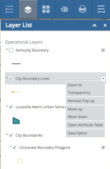
The Map Layers widget shows the layers in the map and allows users to turn them on, off, change the transparency, zoom to that layer, or even open the attribute table. |
 |
The Base Map widget allows users to select from a gallery of available base map layers. |
 |
The drawing widget allows users to add text or draw on the map. Some versions also allow you to measure areas and distances as well. |
 |
The print widget simply outputs the current map image to a PDF or other file format. Users can input their own title and choose from a series of advanced functions such as forcing the map to a particular scale. |
 |
This widget displays a list of predefined spatial bookmarks. Users can add and delete bookmarks and those changes are maintained on your computer unitl you empty your browser cache. |
 |
The Share widget allows users to share a link to the map's current extent in Facebook, Twitter, Google+, e-mail, or via a shorten link. Syntax needed to embed the map in another website is also provided. |
Navigation
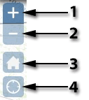
Map Navigation: The navigation controls for the Map Viewer are easy to use and have several nice functions. The image below shows the components of the Navigation widget and a description of each one is provided in the adjacent table. Tips on how to navigate using the Keyboard and Mouse are also provided.
 |
Component | Description |
| 1 | Clicking on the small globe in the widget sets the map extent to the maximum or full extent or basically returns it to statewide. | |
| 2 | Clicking on or between any of the pointers around the small globe pans the viewer in the requested direction. | |
| 3 | Clicking on the house icon sets the map extent to the maximum or full extent or basically returns it to statewide. | |
| 4 | Clicking on this icon will center the map on your location. Note that Location Services must be enabled within your browser or mobile device in order for this function to work. |
Keyboard Navigation: Navigating the map by using the keyboard is very effective. Zooming, panning, and other actions can be performed with a keystroke or combined keystroke and mouse action.
Panning the map can be achived using the arrows keys on the keyboard. The UP arrow pans North, the DOWN arrow pans South, the RIGHT arrow pans East, and the LEFT arrow pans West.
Zooming in and out can be achieved by using the Shift key and either the "+" or the "-" key on a numeric keypad.
Another great way to zoom in is to hold down on the Shift key and then click and drag a rectangle on the map to define the zoom area.
Mouse Navigation: Navigating the map can also be done with the mouse.
Scroll the mouse wheel forward or up to zoom in or backward to zoom out.
Hold the Shift key down, then hold the left mouse button down and drag to draw a rectangle. The map will zoom in to the area of the rectangle.
Working with Layers
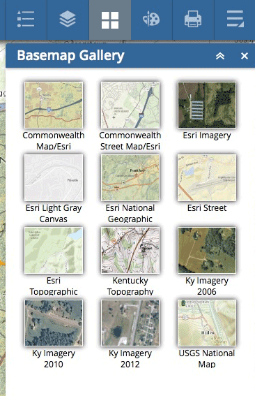
Base Layers: Users have the ability to switch base layers depending on their needs or interests. Some people prefer a street map based view while others like to see landcover, topography, and aerial images as they zoom in closer and closer. These different base layers can be activated using the Base Map Gallery widget that is located with the other tools in the map viewer header. Users have the ability to use the Kentucky Base Map, the Kentucky Topography Map, Aerials from different years, or Esri's topographic or street base. Simply click on the desired base map to make it active.
Thematic Layers: Thematic, or operational, layers are usually the primary focus of the site. Things such as the weather radar, state parks, wastewater treatment plants, and geodetic control points are examples of thematic layers. These layers can be activated by checking the box to the left of the layer name. Clicking on the little pulldown menu to the right of the layer name allows the users to set the transparency, open the attribute table, move it up or down in the list, or zoom to its full extent.
Zoom to . . .
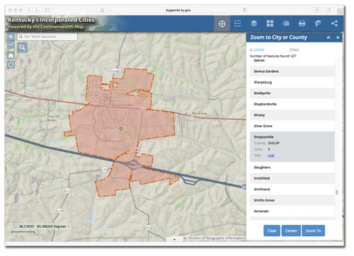
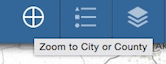
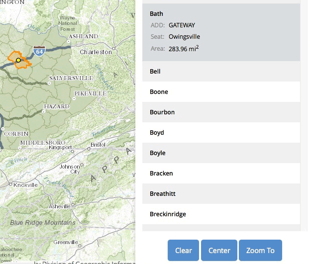
Zooming to a County: Most all of the Kentucky map viewers have widgets with easy to use "Zoom To" menus. The most common are the Zoom to County and Zoom to City widgets. Click on the cross hair icon in the toolbar as shown below to launch the widget.
Use the pulldown menu in the widget to select the item of choice, City or County for example.
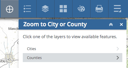
Then, select the desired item from the pulldown menu.
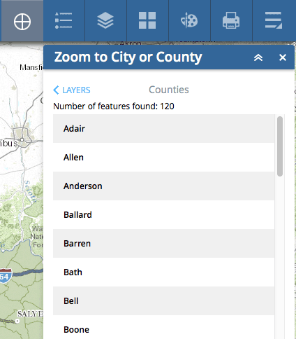
Once selected, the feature will be highlighted on the map. Click on the item in the widget results to view the feature's details. Use the buttons at the bottom of the widget to Clear, Center, or Zoom to the Feature. Closing the widget will remove the selection's highlighting.
Finding an Address on the map
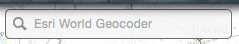
Finding an Address: It is very easy to find an address on the map. Use the geocoding form (Esri World Geocoder) located in the upper left corner of the map viewer (under the title) to input an address. The form can also be used to find a zipcode, city, county, or lat/long.
Type in an address and hit return. See the example below. Note that the tool provides a listing of best match candidates.
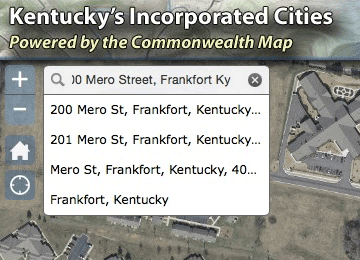
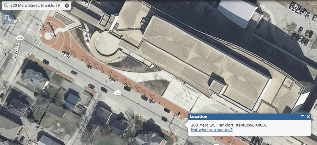
The image below shows the results for a search on 200 Mero Street, Frankfort Ky. The same process can be used to search for city, county, zip code or lat/long values.
Finding a Point on the map
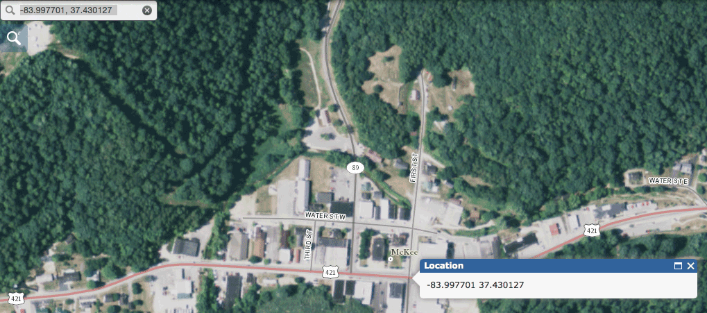
Finding an Point: Finding a point on the map is simple with the Esri World Geocoder. Simply paste or enter a coordinate value in the form and hit return. It is important to note that the tool requires the value be formatted with the longitude value before the latitude value. Make sure to include the "-" before the longitude value (ie. -83.997701, 37.430127).
Enter the appropriate longitude and latitude coordinates in decimal degrees and hit return. See the example above.

Hitting return will zoom the map to the coordinate that was entered. See the example below.
Getting a Map Coordinate
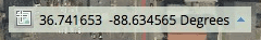
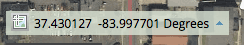
Obtaining a Map Coordinate: The Coordinate Widget is positioned in the lower left corner of the map viewer just above the graphic scale bar. Note that moving the mouse causes the values to change based on the current position of the mouse on the map.
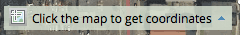
To obtain a map coordinate, click on the icon  at the left of the coordinate values.
Doing this changes the mode of the coordinate tool to allow for getting map coordinates that can be copied. Note that the tool now says "Click the map to get coordinates".
Then, simply click on the map and the coordinate value will be placed in the tool. If you need to copy the value, select it in the tool and hit Ctrl + C then paste the value where you desire.